This undergraduate research project, led by Hunter Wade and supported by Evan Klansnic, investigates how different land use types influence both air pollution (PM₂.₅) and temperature in Salt Lake City, contributing to the broader effort to understand how urban environments affect local environmental health conditions.
Conducted as part of the Health, Air Pollution and Population Initiative in Education and Science Training (HAPPIEST) project: Mapping Personal Heat Exposure in Salt Lake City Using Wearable Sensors at the University of Utah, this subproject was developed and led by Hunter under the mentorship of Alexandra Ponette-González, PhD, with support from graduate researcher Toby Armstrong and undergraduate researcher Evan Klansnic (ArcGIS Pro visualization and route investigation).
This research was supported by the CAP-VPR Research Initiative Seed Grant at the University of Utah (to AG Ponette-González, M. Fry, and N Daher), the Natural History Museum of Utah, and the National Science Foundation (to AG Ponette-González, # 2323996).
Abstract
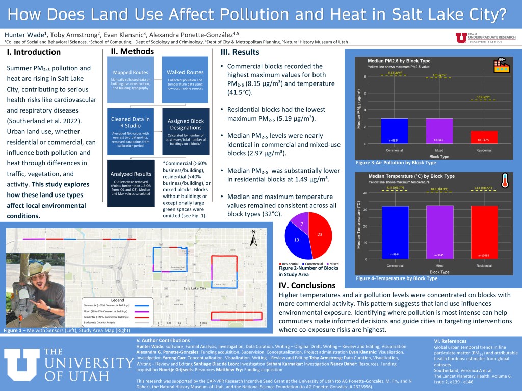
As Salt Lake City experiences rising summer temperatures and persistent air quality concerns, this project investigates how different land use types-commercial, residential, and mixed-use-affect localized environmental conditions. Over six days in June 2025, a team of student and faculty researchers collected real-time temperature and PM₂.₅ data using low-cost portable sensors along four mapped walking routes. Each block was classified by building type, and landscape features such as tree cover and park strips were noted during fieldwork.
Sensor data was cleaned and analyzed in RStudio, with outliers removed to ensure accurate comparisons. We calculated both maximum and median values for PM₂.₅ and heat across land use categories to assess patterns of environmental exposure.
Preliminary findings show that commercial and mixed-use areas tended to have higher maximum pollution and heat levels, while median values revealed subtler but consistent differences across block types. These results highlight the influence of urban form on microclimates and pollution hotspots, suggesting that neighborhood design may play a role in shaping environmental risk. The findings offer insights relevant to public health, environmental equity, and city planning in rapidly growing urban areas like Salt Lake City.
