This undergraduate research project, led by Evan Klansnic, investigates how different park strip materials influence pedestrian heat exposure in Salt Lake City, contributing to the broader effort to understand urban heat mitigation in walkable environments.
Conducted through the University of Utah’s Summer Program for Undergraduate Research (SPUR), the study is part of the Health, Air Pollution and Population Initiative in Education and Science Training (HAPPIEST) project: Mapping Personal Heat Exposure in Salt Lake City Using Wearable Sensors at the University of Utah. Evan developed and led this subproject under the mentorship of Alexandra Ponette-González, PhD, with support from graduate researchers Toby Armstrong and Yarong Cao as well as Nancy Daher, ME, PhD with troubleshooting and setting up the equipment used in this study.
This research was supported by the Office of Undergraduate Research at the University of Utah, the National Institute of Environmental Health Sciences (NIEHS) of the NIH under award R25ES031497, the CAP-VPR Research Incentive Seed Grant, the Natural History Museum of Utah, and the National Science Foundation (NSF Award #2323996).
The content presented here is solely the responsibility of the author and does not necessarily represent the official views of the National Institutes of Health.
Abstract
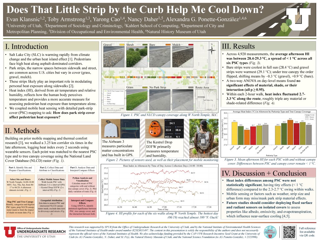
Park strips, the narrow section of land between the sidewalk and the curb, are an important component of land cover within cities. These strips likely play an important role in modulating personal heat exposure within street environments. In this study, we mapped park strip cover along a 3.25 km section of West North Temple in Salt Lake City and categorized areas as grass, gravel, bare, mulch, shrub and no park strip. We walked this route on six summer afternoons (4:00 to 6:00pm) from 06/17/25 to 06/28/25. A wearable temperature and humidity sensor recorded heat index every two seconds (n=4,920 observations) and each heat index record was matched in ArcGIS Pro to the nearby park strip cover type, as well as to a canopy/non-canopy category derived from the National Land Cover Database canopy raster.
Heat index varied by < 1°C among the six park strip cover types, with a range of 28.4 °C to 29.3 °C across all observations. This included park strip cover segments classified as shaded versus unshaded, where the differences never exceeded 1 °C. By contrast, intra-route variation in heat index within the two-hour sample window had a 2.7 – 3.3 °C range.
We did not detect significant differences in heat index among park strip cover types in this study, a pattern which may be due to the measurement method (mobile) or the relative influence of other factors such as intra-route variation, park strip characteristics (e.g., width), or surrounding urban form. Therefore, we suggest that future work employ fixed measurements of surface and radiant temperature on individual park strip cover types to assess how park strip cover affects pedestrians and the surrounding microclimate. Additional interventions such as tree planting and installation of permanent shade structures that allow more direct protection from the sun in this area could also be considered alongside park strip management.
